
How Forest Department Identifies Tigers and Their Territories in Jim Corbett
Tiger territory identification in Jim Corbett is one of the most sophisticated wildlife management processes in India. Every stripe, every scrape on a tree, every paw impression in the mud tells a story and the forest department has learned to read all of it. Understanding how tigers claim, defend, and move through their ranges is not just scientific curiosity. It directly shapes how Corbett is managed, how safaris are planned, and how this landscape continues to hold one of the world’s healthiest wild tiger populations.
1) What Is Tiger Territory Identification in Jim Corbett and Why It Matters
The Science Behind Mapping a Tiger’s World
A tiger’s territory is not a fixed fence. It is a fluid, contested space shaped by prey density, water access, competition from rival tigers, and seasonal pressure. Forest department tiger monitoring in Corbett involves piecing together dozens of data streams camera images, patrol logs, GPS points, pugmark casts to build a living picture of where each individual tiger moves and what they consider home.
Corbett spans over 1,300 square kilometres across its core and buffer zones. Mapping every tiger’s range within that landscape requires year-round effort, not just during the annual census window. This work is what keeps Corbett’s ecosystem balanced.
Why Territory Data Matters for Conservation and Safari Management
Territory data directly influences which zones remain open to safaris and which are protected as inviolate core areas. When the department identifies a tigress with cubs in a particular zone, access is restricted. For visitors, this data translates into better, more informed safari experiences.
Scent Marking and Pheromone Signals Along Forest Trails
Walk any trail in Dhikala or Bijrani and experienced naturalists will pause at particular spots — a bush sprayed at nose height, a patch of ground with raked soil. These are territorial marking behavior signals that tigers leave deliberately. Pheromone scent marking communicates the resident tiger’s identity, reproductive status, and the message that this range is taken.
Tigers refresh these scent posts regularly, especially along boundaries where ranges overlap. Beat guards and field staff know these locations intimately. They monitor whether the same individual is refreshing the marks or whether a new tiger has moved in.
Scratch Marks, Scrapes, and Visual Territory Indicators
Scratch marks on tree trunks serve a dual purpose — scent from inter-digital glands transfers to the wood, and the height of the marks signals body size to rival tigers. These visual cues are cross-referenced with camera trap tiger identification in Jim Corbett to match physical evidence to known individuals.
Scrapes on the ground — raked debris left near a marking site — are another consistent indicator. Field staff document these locations and GPS-stamp them, feeding data into the department’s range mapping system.
Vocalization as a Territorial Boundary Signal
The roar of a Bengal tiger carries over three kilometers through dense forest. Vocalizations are used to broadcast presence and warn other tigers away from core territory. Forest staff familiar with individual tigers can often distinguish calls by pitch and rhythm — adding another layer of behavioural data to the identification record.
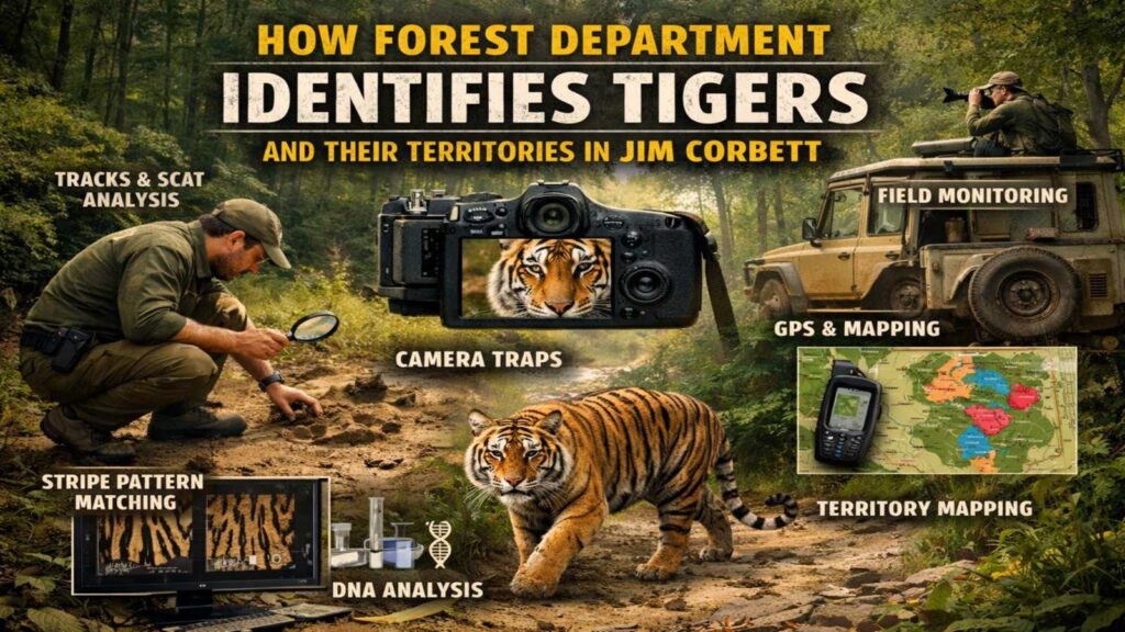
2) Tiger Identification Methods Used in Jim Corbett National Park
Stripe Pattern Recognition: Nature’s Fingerprint System
No two tigers share the same stripe pattern. This stripe pattern recognition principle is the backbone of individual tiger identification in Jim Corbett National Park. Camera trap images are analyzed by forest department teams who cross-reference flank patterns, facial markings, and ear notches against an existing photo database.
Each identified individual receives a unique code. As sightings accumulate over years, the department builds detailed profiles covering home range, prey preferences, social interactions, and reproductive history.
Pugmark Identification and Plaster Cast Analysis
Pugmark identification has a long history in Indian tiger monitoring. Field teams take plaster casts of clear paw impressions found along riverbeds, dirt roads, and patrol trails. The dimensions, shape, and inter-pad spacing of a pugmark can reliably distinguish individuals, particularly when collected systematically across a defined grid.
While camera traps have largely replaced pugmark analysis as the primary tool, cast records still provide valuable supplementary data — especially in zones where dense vegetation limits camera coverage.
Individual Tiger Identification Through Behavioural Profiling
Beyond physical markings, the department builds behavioural profiles for each known tiger. Prey preferences, movement timing, favoured water sources, and responses to vehicles all form part of the record. This profiling helps predict movement patterns and improves the accuracy of tiger range mapping in Jim Corbett Forest.
3) How the Forest Department Conducts Tiger Monitoring in Corbett
Camera Trap Tiger Identification Across Core and Buffer Zones
Camera trap monitoring is the most powerful tool currently deployed across Corbett. Hundreds of camera stations are positioned across core safari zones and deep buffer areas. Each station captures images triggered by motion, day and night, building a continuous record of tiger activity.
Camera trap tiger identification in Jim Corbett generates thousands of images per census cycle. Trained analysts match these images to the existing individual database, flagging new, unrecognised tigers as potential new residents or transient individuals passing through.
Radio Collar Tracking and GPS-Based Movement Mapping
Select tigers — particularly those in conflict zones or newly dispersed young males — are fitted with radio collars. Radio collar tracking enables real-time GPS-based movement mapping, allowing the department to monitor dispersal routes, wildlife corridor use, and the boundaries where one tiger’s range meets another’s.
This data is critical for identifying bottleneck zones where tiger movement between Corbett and surrounding forest blocks is most vulnerable to habitat fragmentation.
Field Staff, Beat Guards, and Ground-Level Patrol Data
Technology only tells part of the story. Beat guards who walk the same forest blocks daily build an unmatched intuitive knowledge of local tiger behaviour. Their patrol observations — fresh kills, pugmarks, territory spray sites, alarm calls from Chital and Sambar — feed into the department’s data system and often flag changes in tiger presence before camera traps confirm them.
4) Bengal Tiger Territory Size in Corbett: Zone-by-Zone Breakdown
Dhikala Zone: The Largest Tiger Territory in Corbett
The Bengal tiger home range varies significantly by sex and individual. Males in Corbett’s Patli Dun valley — the heart of the Dhikala zone — can hold territories covering 60–100 square kilometers or more. Dhikala’s open grasslands and dense riverine forest support exceptional prey density, making it the zone with the highest tiger density in the reserve.
Bijrani, Jhirna, and Durga Devi: Overlapping Ranges and Shared Corridors
In zones like Bijrani, Jhirna, and Durga Devi, territories are more compressed due to the mix of core and buffer habitat. Female tigers in these zones typically hold ranges of 20–40 square kilometres. Overlapping ranges between females and resident males create complex social maps that the department tracks continuously.
How Territory Size Shifts with Season and Prey Availability
During summer, as water sources shrink and prey concentrates near rivers and waterholes, tiger home ranges temporarily contract. In monsoon, when prey disperses through the forest, ranges expand. Bengal tiger territory size in Corbett is therefore a seasonal variable — not a fixed statistic — which is why the department updates its territory maps quarterly.
5) Which Zones Offer the Best Tiger Sighting Opportunities
Dhikala Zone: Highest Tiger Sighting Density in Jim Corbett
Dhikala remains the gold standard for tiger sightings in the reserve. The combination of large resident tiger territories, open chaurs (grasslands) that allow long-distance visibility, and high prey density makes sighting probability significantly higher here than in other zones.
Bijrani and Jhirna Zones: Consistent Territorial Tiger Activity
Bijrani delivers consistently strong tiger sighting records for day visitors, with its grassland edges and mixed forest providing classic ambush habitat that tigers use actively. Jhirna, the only zone opens year-round including monsoon, has resident territorial tigers whose ranges are well-documented by the department, making sightings predictable across all seasons.
How to Plan a Safari Around Tiger Territory Hotspots
Choosing the right zone based on tiger territory data is the single most important safari planning decision.
Best Safari Timing to Align with Territorial Tiger Activity
Tigers are most active during early morning and late afternoon safaris. These are also the hours when territorial marking activity peaks just after dawn, resident tigers re-mark boundaries before settling for the day. Aligning safari timing with these territorial rhythms significantly improves sighting odds.
Photography Tips for Documenting Tigers in Their Natural Territory
When you encounter a tiger, stay still and let the animal set the pace. Tigers often pause at familiar scent-marking trees these are extraordinary moments to document territorial marking behavior in the wild. Keep cameras ready at all times along grassland edges and dry riverbeds.
Jim Corbett is home to over 250 tigers, making it one of the highest tiger-density reserves in India. The forest department conducts a tiger census every four years using camera traps across the entire reserve, and Corbett consistently records the highest tiger population of any single tiger reserve in the country.
Dhikala zone has the highest tiger sighting density in Jim Corbett. Its Patli Dun valley, open chaurs, and large resident tiger territories combine to produce the most reliable sighting conditions in the entire reserve.
Forest department tiger monitoring in Corbett uses camera trap tiger identification, radio collar tracking, pugmark analysis, scent marking site monitoring, and beat guard patrol data. All these streams are integrated into territory maps that are updated regularly.
Bengal tiger territory size in Corbett varies by sex. Male tigers can hold ranges of 60–100 square kilometers in prey-rich zones like Dhikala. Female tigers typically maintain ranges of 20–40 square kilometers. Territory size also shifts seasonally with prey movement.
Book an early morning Gypsy safari through Dhikala zone and focus your route on the open chaurs and Ramganga riverbanks. These are the core territorial zones where resident tigers are most frequently sighted. Staying at Dhikala Forest Lodge gives you access to multiple sequential safaris, maximising your sighting probability.
The tiger census in Corbett uses a camera trap grid setup deployed across both core and buffer zones simultaneously. Hundreds of paired cameras are positioned at known wildlife trails and territory markers. Images collected over a defined period are then analysed using stripe pattern recognition software to count distinct individuals and map their ranges.
Dhikala is widely regarded as the best zone in Jim Corbett to see tigers in the wild, followed closely by Bijrani for day visitors. Jhirna is the best option during monsoon months when other zones are closed.
It’s fascinating to see how the forest department in Jim Corbett uses such detailed tracking methods—like pugmarks and camera traps—to understand tiger behavior and territory dynamics. This level of monitoring not only supports conservation efforts but also helps in planning eco-friendly tourism like safaris. The fluid nature of tiger territories really highlights the complexity of wildlife management in such a rich ecosystem.